Hole-in-the-Rock Adventure 2010

IntrepidXJ

Explorer
Hope you don't mind another report from my archives...this one from about a year ago.

--------------------------

Thursday, April 8, 2010 | Day 1

IMG_6280.jpg


Late last year I finally decided to put together a trip that has been on my to-do list for way to long. I needed to finish driving the Hole-in-the-Rock Expedition (San Juan Mission) Route by driving the Hole-in-the-Rock Trail. I had driven pretty much all of the other sections of the route that are drivable except for this one. This was planned as a three day trip so that we could take our time and also get in some hiking along the trail. My adventure started on Thursday, which was the day before we were supposed to meet at the trail. I wanted to take my time driving to the trail near Hall's Crossing and also make a few stops along the way.

After stopping at Back of Beyond Books in Moab and filling up my gas tank in Blanding, I set off west on UT-95. Of course I had to stop at 'Salvation Knoll' since it was an important landmark to George Hobbs and the Hole-in-the-Rock Expedition.

IMG_6205.jpg


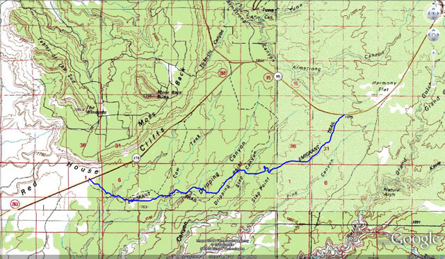
From Salvation Knoll I made my way further west to my first trail of the trip. On my maps, I noticed there was a segment of the Hole-in-the-Rock trail that I had not driven that connected UT-95 and UT-276. After some research into the route, I found that it is still a valid route that is open to motorized travel, so I figured I would give it a try.

When I reached the turnoff from the highway, I was greeted with a well maintained county road. The sign even marked it as part of the Mormon Trail

IMG_6208.jpg


After a mile or two of the easy pretty well maintained road, it got a little rougher and crossed some slickrock sections
IMG_6219.jpg


IMG_6243.jpg


Eventually I reached a large section of slickrock that dropped off into a small canyon. I didn't immediately find a way down, so I parked the Jeep and hiked around for a while until I picked up the trail again. From this point on, the well maintained county road was left behind and the much rougher and narrower trail continued. It was hard to follow in many places and required that I hike ahead first, but there were enough signs along the way to reassure myself that I was on the right track.

Marker along the route indicating this was part of the Hole-in-the-Rock Expedition
IMG_6249.jpg


IMG_6254.jpg
 
Last edited:

IntrepidXJ

Explorer
Dropping down
IMG_6258.jpg


IMG_6266.jpg


Dripping Springs Canyon with more markers
IMG_6267.jpg


After using my navigations skills to keep on track, I eventually reached UT-276 and was back on the pavement again. Here is the route I drove, marked in blue.
DrippingCanyonSmall.jpg


My next destination was to take the Clay Hills Crossing Road all the way to the San Juan River. During the original expedition, there was a side reconnaissance this direction over the Whirlwind Bench to the Clay Crossing. This is an easy maintained county road that is used as a take-out by rafters on the San Juan. While the road is not difficult, the scenery along the Red House Cliffs is nice.

IMG_6292.jpg


IMG_6300.jpg


This was a nice high-speed road, so I was back at the highway in no time ;)

My next stop was along the highway at the plaque marking Clay Hill Pass. This was another major obstacle for the original expedition, which spent eight days building a road down to the bottom for their wagons.

IMG_6313.jpg


IMG_6314.jpg
 

IntrepidXJ

Explorer
A little further down the highway, I made yet another stop. This time it was to check out the Castle Ruin. George Hobbs of the Hole-in-the-Rock Expedition spoke of these 'Cliff Dweller' ruins in his account of the trip.

IMG_6337.jpg


IMG_6343.jpg


IMG_6347.jpg


IMG_6359.jpg


IMG_6370.jpg


IMG_6365.jpg
 

IntrepidXJ

Explorer
After my visit to Castle Ruin, I made my way to Hall's Crossing where I met a few people from our group at the campground. I was not planning on camping there, I so made my way over to Cal Black Airport and fueled up before heading to Lake Canyon.

Navajo Mountain in the distance
IMG_6376.jpg


On my way to Lake Canyon, I got to check out some of the old wagon tracks from the expedition which had carved grooves into the slickrock.

IMG_6384.jpg


IMG_6388.jpg


Deep wagon tracks
IMG_6410.jpg


When I reached the East Fork of Lake Canyon, I met up with Dave, Rob and Jared and we headed out to the washout of the Lake Canyon portion of the trail.

IMG_6416.jpg


The original Hole-in-the-Rock Jeep Trail used to drop into Lake Canyon and then cross to the other side. A few years ago, the sand that fills the canyon (remnants of Lake Pagahrit) where the trail crossed the canyon was washed out by flash flooding. The lighting wasn't ideal, but you can see the washout of the sand in the bottom of the canyon below.

IMG_6421.jpg


IMG_6427.jpg


From the washout, we headed back up canyon a little ways and setup camp for the night. It was a great start to a great trip!

Stay tuned for photos from the next four days.....I took a lot of pictures and it's going to take some time for me to go through them all!
 

IntrepidXJ

Explorer
Friday, April 9, 2010 | Day 2

After a cool night in Lake Canyon we were up early and broke down camp. Before heading out, Jared and I went for a hike up Lake Canyon to warm up. When we made it back to camp, we headed back out of Lake Canyon and headed towards the Nokai Dome shortcut which would take us to the Halftrack Junction.

Passed this along the way
IMG_6455.jpg


Stopped at Halftrack Junction
IMG_6464.jpg


When we reached the junction, we made contact with the rest of the group who were headed up the trail behind us. We continued on, knowing they would catch us soon enough.

and they did...
IMG_6484.jpg


IMG_6503.jpg


However, shortly after joining the rest of the group, our small group left the main group again and headed the other direction. We went down the old trail and back to the washed out section in Lake Canyon for a different perspective.

IMG_6517.jpg


The washout in Lake Canyon from above
IMG_6528.jpg


IMG_6532.jpg


Lake Canyon and the Henry Mountains
IMG_6550.jpg
 

IntrepidXJ

Explorer
After some lunch, we were back on the trail again. After crossing through Death Valley, we were soon approaching Grey Mesa. First we passed the old wagon track that the Hole-in-the-Rock pioneers had used to get their wagons down off of Grey Mesa.

IMG_6559.jpg


Narrow and steep
IMG_6562.jpg


IMG_6570.jpg


IMG_6579.jpg


We would not be heading up this way. Instead we would be climbing up onto Grey Mesa via an old rough trail blasted into the slickrock by prospectors.

IMG_6600.jpg


IMG_6604.jpg
 

IntrepidXJ

Explorer
IMG_6606.jpg


IMG_6607.jpg


IMG_6608.jpg


Once on the mesa, we were greeted with a few miles of smoother roads, which was a welcome relief from the miles of broken and bumpy slickrock we had just crossed.

IMG_6620.jpg


Views of the Great Bend of the San Juan River from above
IMG_6625.jpg
 

IntrepidXJ

Explorer
Once we headed off the mesa on the other side, we were traveling on slickrock once again.

IMG_6644.jpg


Headed down 'The Chute'
IMG_6651.jpg


IMG_6663.jpg


Shortly before sunset we finally reached the end of the trail. It was a long day of driving.

IMG_6678.jpg


Dave and I setup camp away from the rest of the larger group, had some dinner and went to bed early.

IMG_6700.jpg


It was definitely a long day behind the wheel, but it was also a lot of fun. Here's a couple action shots of me...

Getting a little air under the rear tire. Taken by Alex.
DSC_8403.jpg


The following two pictures were taken by Dave on the way back to the washout in Lake Canyon
IMG_4720.JPG


IMG_4756.JPG


Stay tuned for day's 3-5!
 

IntrepidXJ

Explorer
Friday, April 10, 2010 | Day 3

After a near perfect night camping, we were up early again so that Dave and I could hike down to Cottonwood Hill from the end of the 4x4 trail. On our way down we passed a number of grooves carved into the rock from the cables used to drag the wagons up the hills.

IMG_6732.jpg


View of Aladdin's Lamp along the way.
IMG_6741.jpg


The Hole-in-the-Rock in the distance, beyond Lake Powell. Cottonwood Canyon below.
IMG_6738.jpg


The trail down into Cottonwood Canyon. This is where we stopped and turned around.
IMG_6748.jpg


Nice scenery along the way
IMG_6751.jpg


Another trail marker
IMG_6752.jpg


You can see the trail cut up the side of Cottonwood Hill. The hike back up was not as easy as it was on the way down.
IMG_6754.jpg


The Hole-in-the-Rock in the distance.
IMG_6780.jpg
 

IntrepidXJ

Explorer
As close-up as I could get a photo of the Hole-in-the-Rock. When the pioneers encountered the cliffs down to the river from the other side, this cleft in the rock was the only way down they could find. They managed to blast a very steep wagon road from the top down to the river. This ordeal is where the name Hole-in-the-Rock expedition came from, though they encountered numerous obstacles in the terrain along the way.

IMG_6777.jpg


Back near the top again.
IMG_6789.jpg


Rob & Jared back at camp
IMG_6794.jpg


Navajo Mountain towers above as we start the trek back. Our goal was to take it slow on the way back and stop for a few more hikes.

IMG_6803.jpg


A few slickrock fins to climb and descend.
IMG_6819.jpg


Parked near the bottom of 'The Chute' to go on our next hike of the day.
IMG_6827.jpg


On our way...
IMG_6829.jpg


IMG_6834.jpg
 

IntrepidXJ

Explorer
Jeeps below us.
IMG_6831.jpg


Oasis in the canyon.
IMG_6835.jpg


There were a number of large potholes filled with water we had to go around.
IMG_6840.jpg


Finally, we reached our destination: Old Settler Natural Bridge

IMG_6860.jpg


IMG_6843.jpg


Dave on the steep slickrock
IMG_6875.jpg


Fun with reflections
IMG_6879.jpg


IMG_6882.jpg
 

IntrepidXJ

Explorer
Can you spot Jared high above?
IMG_6893.jpg


Back at the Jeeps....another reflection
IMG_6903.jpg


Our next obstacle....The Chute...straight ahead
IMG_6910.jpg


Going up!
IMG_6923.jpg


IMG_6928.jpg


Ledge at the top of 'The Chute'
IMG_6932.jpg


Back up on the mesa! Heading towards the Henry Mountains
IMG_6936.jpg
 

IntrepidXJ

Explorer
Our next hike would take us down The Rincon trail a little ways. We wanted to try and find a high undercut pouroff into Iceberg Canyon.

After about a mile and a half, we were staring down into Iceberg Canyon, but not at the right location. We wanted to get to the pouroff directly across the canyon from this viewpoint.

IMG_6938.jpg


Photo of me
IMG_6947.jpg


Soon we were scrambling up and over some steep slickrock domes to reach the other viewpoint. We did finally make it!

Long way down
IMG_6963.jpg


IMG_6980.jpg


Apparently, men are required to throw rocks from high ledges, so we abode...

IMG_6970.jpg


IMG_6983.jpg


Great scenery along the hike as well
IMG_6985.jpg
 

IntrepidXJ

Explorer
Once we made it back to our vehicles, we were back on the trail again.

IMG_6991.jpg


Headed down from Grey Mesa

IMG_6996.jpg


When it started getting late again, we found a large area of slickrock to camp for the night.

IMG_6998.jpg


IMG_7010.jpg


We were treated to a colorful sunset.
IMG_7036.jpg


Checking out our videos from earlier in the day before turning in for the night.
IMG_7043.jpg


It was another long and very fun day! I'll have great memories from this day :)
 

IntrepidXJ

Explorer
Sunday, April 11, 2010 | Day 4
Monday, April 12, 2010 | Day 5

We had camped pretty close to the end of the trail the previous night, so once we were up and packed up we made our way back to the highway. I didn't stop for anymore photos on the way out. Once back at the highway, a few of us stopped at Cal Black Memorial Airport to fuel up. Everyone else was heading back home, but I had one more day to do some exploring. On my way back towards Blanding I decided to try and head down Red Canyon to Lake Powell.

IMG_7055.jpg


It started out as a recently maintained county road through some great scenery
IMG_7051.jpg


Henry Mountains in the distance
IMG_7061.jpg


IMG_7066.jpg


IMG_7072.jpg


Eventually the road started to get a little rougher and had not been maintained recently. There were a lot of rocks and small boulders that had fallen from the canyon walls and had to be avoided.....even one large boulder I was able to squeeze by.

IMG_7077.jpg


IMG_7079.jpg
 

Forum statistics

Threads
187,449
Messages
2,894,654
Members
228,402
Latest member
rpinkall1
Top