You are using an out of date browser. It may not display this or other websites correctly.
You should upgrade or use an alternative browser.
You should upgrade or use an alternative browser.
San Francisco to Ushuaia in an 87 4Runner.
- Thread starter defrag4
- Start date
defrag4
Road Warrior
I'm shuffling through my pictures here for some of Bogota. Looks like we didn't actually take much.
Bogota is a huge city, full of history, and culture. It is one of the largest cities in all of South America. Needless to say, driving around in it is a stressful nightmare that does not lend well to snapping photos.
We eventually settled on a hostel somewhere up in the "La Candelaria" historic district for our first night. The next morning I pulled the truck out of the micro-machine garage and caught the tail-light on the garage door. A couple minutes with some ducttape and screws and we were back in business.
Our destination for the day was Bogotas famous Museo Del Oro, home to largest collection of Pre-Hispanic gold artifacts in the WORLD. I have really been looking forward to this museum since reading about it before we even started our trip.
A boss chief and his bling

Believe it or not this was a nose-ring! You can see 4 shamans sitting om top of some sort of bird. During their rituals, the birds supposedly carried the shamans up into the heavens where they could communicate with other shamans on the happenings of the world.


This mummy was found in great condition in a sacrificial burial chamber.

Meditation or just taking a crap? You decide!

Poporo Quimbaya, A famous piece of Pre-Colombian artifact. The Poporo was used to hold lime dust, which was added to the mouth while chewing Coco leaves to enhance their effect. This particular piece jumpstarted the Museo Del Oro in Colombia and is very famous/important in Colombia.

The Muisca raft of "El Dorado". Legend has it, the chief would cover his body with gold powder, raft out to the middle of the lake and chunk gold and emerald pieces into the water to please the Gods. Many people have dredged and scoured the lake in search of these valuable pieces but as of yet have found nothing much.

They have a trippy presentation at the end of the museum tour. You are placed in a circular room where they crank up some ancient chanting music and space out to a laser light show showcasing the gold artifacts.


The gold museum had a great audio tour (in english!) I suggest everyone check it out while they are in Bogota.
After the museum we jetted over to the Bogota Marriot. Lauren's dad had some points to share and was gracious enough to get us a room while in Bogota for my birthday! Thanks Ed!
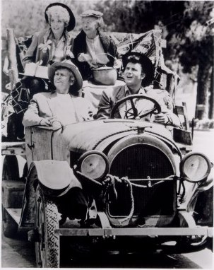
We felt kinda like the Clampetts pulling up to this ritzy hotel in our muddy busted up truck with duct tape holding taillights together.
All our problems washed away when we got to the room and indulged in unlimited hot water showers, cable TV, and room service. Oh and a delicious pillow menu
ILL TAKE ONE OF EACH!


The next morning, we stretched that check-out time till they were breaking down the door.
Hopped in the truck and headed south.
Bogota is a huge city, full of history, and culture. It is one of the largest cities in all of South America. Needless to say, driving around in it is a stressful nightmare that does not lend well to snapping photos.
We eventually settled on a hostel somewhere up in the "La Candelaria" historic district for our first night. The next morning I pulled the truck out of the micro-machine garage and caught the tail-light on the garage door. A couple minutes with some ducttape and screws and we were back in business.
Our destination for the day was Bogotas famous Museo Del Oro, home to largest collection of Pre-Hispanic gold artifacts in the WORLD. I have really been looking forward to this museum since reading about it before we even started our trip.
A boss chief and his bling
Believe it or not this was a nose-ring! You can see 4 shamans sitting om top of some sort of bird. During their rituals, the birds supposedly carried the shamans up into the heavens where they could communicate with other shamans on the happenings of the world.
This mummy was found in great condition in a sacrificial burial chamber.
Meditation or just taking a crap? You decide!
Poporo Quimbaya, A famous piece of Pre-Colombian artifact. The Poporo was used to hold lime dust, which was added to the mouth while chewing Coco leaves to enhance their effect. This particular piece jumpstarted the Museo Del Oro in Colombia and is very famous/important in Colombia.
The Muisca raft of "El Dorado". Legend has it, the chief would cover his body with gold powder, raft out to the middle of the lake and chunk gold and emerald pieces into the water to please the Gods. Many people have dredged and scoured the lake in search of these valuable pieces but as of yet have found nothing much.
They have a trippy presentation at the end of the museum tour. You are placed in a circular room where they crank up some ancient chanting music and space out to a laser light show showcasing the gold artifacts.
The gold museum had a great audio tour (in english!) I suggest everyone check it out while they are in Bogota.
After the museum we jetted over to the Bogota Marriot. Lauren's dad had some points to share and was gracious enough to get us a room while in Bogota for my birthday! Thanks Ed!
We felt kinda like the Clampetts pulling up to this ritzy hotel in our muddy busted up truck with duct tape holding taillights together.
All our problems washed away when we got to the room and indulged in unlimited hot water showers, cable TV, and room service. Oh and a delicious pillow menu
ILL TAKE ONE OF EACH!
The next morning, we stretched that check-out time till they were breaking down the door.
Hopped in the truck and headed south.
defrag4
Road Warrior
We popped open our guidebook and searched for "What's Next" while we drove south from Bogota.
Lauren found a short blurb describing a strange geological area of Colombia. TheDesierto Tatacoa (Tatacoa Desert) is described as one of the "most attractive natural settings" in Colombia.
The guidebook described large sand pillars painted with orange and yellow hues, 30 foot deep eroded gullies, and miles upon miles of open land. It also stated that the Tatacoa Desert is one of the best places in the world for star-gazing due to lack of light pollution and close proximity to the equator, making it possible to view both the Northern and Southern hemisphere constellations. Sounds good!
Volcanoes popping up on the horizon

I spy a thin snaking road on our map to the desert. Bored of the highway the 4Runner is happy to be back on dirtroads.

Some of the scenery along our winding dirt path


After a few hours of back-roads crossing through many small pueblos who probably wondered how the hell these gringos got out here, we finally arrived on the out-skirts of the desert.

Pushing further in, the grey and black sand gave way to some amazingly beautiful orange/yellow/red sandstone formations. It reminded me of similar formations we had seen back on the Colorado Plateau in the U.S


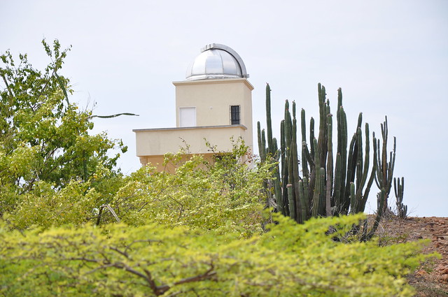
We also passed by an observatory out here, the stars must be pretty epic for them to build this thing out in the middle of nowhere.
We bounced along through the desert for a few hours searching for the perfect campspot. This being a desert and all it was friggin' hot and shade trees were practically non-existent. I spotted 1 lone tree way off in the distance, pulled off the road and did some 4x4 adventuring.
Read the rest of the story and more pics here!
http://homeonthehighway.com/desierto-tatacoa-the-tatacoa-desert-colombia
Lauren found a short blurb describing a strange geological area of Colombia. TheDesierto Tatacoa (Tatacoa Desert) is described as one of the "most attractive natural settings" in Colombia.
The guidebook described large sand pillars painted with orange and yellow hues, 30 foot deep eroded gullies, and miles upon miles of open land. It also stated that the Tatacoa Desert is one of the best places in the world for star-gazing due to lack of light pollution and close proximity to the equator, making it possible to view both the Northern and Southern hemisphere constellations. Sounds good!
Volcanoes popping up on the horizon
I spy a thin snaking road on our map to the desert. Bored of the highway the 4Runner is happy to be back on dirtroads.
Some of the scenery along our winding dirt path
After a few hours of back-roads crossing through many small pueblos who probably wondered how the hell these gringos got out here, we finally arrived on the out-skirts of the desert.
Pushing further in, the grey and black sand gave way to some amazingly beautiful orange/yellow/red sandstone formations. It reminded me of similar formations we had seen back on the Colorado Plateau in the U.S
We also passed by an observatory out here, the stars must be pretty epic for them to build this thing out in the middle of nowhere.
We bounced along through the desert for a few hours searching for the perfect campspot. This being a desert and all it was friggin' hot and shade trees were practically non-existent. I spotted 1 lone tree way off in the distance, pulled off the road and did some 4x4 adventuring.
Read the rest of the story and more pics here!
http://homeonthehighway.com/desierto-tatacoa-the-tatacoa-desert-colombia
defrag4
Road Warrior
Water goes quick in the desert and after 4 days we had exhausted our supply. Regrettable we pulled up our roots and bounced out of the desert back onto the "highway".

We passed the Rio Magdalena, the most important river in all of Colombia. The river runs throughout Colombia. Its life-giving watershed is responsible for 86% of Colombia's GDP. Understandably, Colombians love this river.

We were headed to San Agustin. A small town in Southern Colombia, home to very important pre-Colombian artifacts. San Agustin and the surrounding areas are littered with tons of relics from various civilizations who lived in the Andes mountains from as early as 3300 B.C. all the way up to 17th century.
Not much is known about these ancient cultures. Researchers have found many large stone carvings, evidence of tool use, burial chambers, and religious artifacts. But no solid information as far as politics, social structure, trade, etc.
We found a great hostel up in the mountains who let us camp on there lawn for $5/day. Cold showers but fast internet!

And the worlds wussiest dog I have ever seen. Meet Fresa (Strawberry). Just in case your 10 gram dog was too intimidating, its a good idea to dress it in a pink apron.

The next morning we headed out to the main archeological site. Paid our entrance fee and started touring the grounds. The scientists found these large sculptures scattered all throughout the mountains and moved many of them to this site for further research/display. I like the little protective umbrellas they built for them.

With no signage or guide to tell us what these statues actually meant I went ahead and came up with my own ideas...
"The Skier"

"The Food Baby"

"Mr. Burns"

The Wanker

Ancient Valentines Day card

Read the rest of the story and tons more pics at http://homeonthehighway.com/san-agustin-archaeological-park-colombia
We passed the Rio Magdalena, the most important river in all of Colombia. The river runs throughout Colombia. Its life-giving watershed is responsible for 86% of Colombia's GDP. Understandably, Colombians love this river.
We were headed to San Agustin. A small town in Southern Colombia, home to very important pre-Colombian artifacts. San Agustin and the surrounding areas are littered with tons of relics from various civilizations who lived in the Andes mountains from as early as 3300 B.C. all the way up to 17th century.
Not much is known about these ancient cultures. Researchers have found many large stone carvings, evidence of tool use, burial chambers, and religious artifacts. But no solid information as far as politics, social structure, trade, etc.
We found a great hostel up in the mountains who let us camp on there lawn for $5/day. Cold showers but fast internet!
And the worlds wussiest dog I have ever seen. Meet Fresa (Strawberry). Just in case your 10 gram dog was too intimidating, its a good idea to dress it in a pink apron.
The next morning we headed out to the main archeological site. Paid our entrance fee and started touring the grounds. The scientists found these large sculptures scattered all throughout the mountains and moved many of them to this site for further research/display. I like the little protective umbrellas they built for them.
With no signage or guide to tell us what these statues actually meant I went ahead and came up with my own ideas...
"The Skier"
"The Food Baby"
"Mr. Burns"
The Wanker
Ancient Valentines Day card
Read the rest of the story and tons more pics at http://homeonthehighway.com/san-agustin-archaeological-park-colombia
defrag4
Road Warrior
We hit the highway once again from San Agustin. Looking at the map we are so close to Ecuador we could taste it.
There are 2 routes from San Agustin towards the border. One involves a bit of back-tracking north to catch another highway back south again. I hate going backwards. The other route led us straight down to Ecuador but our friends at fromAtoB.org warned us of poor road conditions. Apparently the route between Mocoa and Pasto was very rough, rugged, and dangerous with lots of wash-outs, large trucks, and little clearance between you and a sheer cliff drop-off.
Being the kind of people who usually hear good advice and then completely disregard it, we of course chose to take the hard route.
It started off easy enough from San Agustin. We were on smooth well-maintained highway. After about an hour I started to wonder what the hell AtoB was talking about...
We were in some pretty remote country, apparently popular with Colombian FARC and guerrillas. The military presence was strong along the highway. We passed a few of these bad-*** truck TANKS.

We hit the town of Mocoa and the pavement ran out. We were driving on a very poor rubble road. I checked the maps and GPS a few times to confirm we were on the right track. Guess this must be the rough part they were talking about?
The poor road started to wind up into the side of the mountain. This road is the most direct route between the border and the interior of Colombia's Amazon jungle. It is primarily used by hardcore semi-trucks hauling logs/goods and the occasional lost gringo.

The road was chopped out of the side of the mountain. You could see many wash-outs where it completely had fallen away and road crews dug deeper into the side of the mountain to keep on truckin. The drive was actually quite beautiful. We were inside a mix of cloudforest and rugged mountains. We had to drive through tons of waterfalls and rivers which were slowly eroding into a muddy soup which made traction diffucult.
Eroding Cliff roads+No traction+No guardrails=Sketchy

In many parts you would have to stop before a blind corner and listen for a giant truck coming and sounding his horn. If you hear the horn you better back up and get the hell out of the way before you get run off the cliffs.

We plied this unpaved mountain route for most of the day. I think in total the route was less than 100 miles but it took us around 7 hours or so to cross. When we finally reached pavement I got out and kissed it.
Sweet sweet tarmac!

We pushed on spent a night at a hostel in Pasto near the Ecuador border. Next morning we were up and headed to the border.
One last stop before we cross though. Ever since I first saw a picture of the Las Lajas church I knew we had to visit it. The pictures made it same like a surreal castle nestled in a magnificent valley, the whole place looks unreal.

The inspiration for the church's creation was a result of a miraculous event in 1754 when an Amerindian named Maria Mueces and her deaf-mute daughter Rosa were caught in a very strong storm. The two sought refuge between the gigantic Lajas (Stone walls), when to Maria Mueces's surprise, her mute daughter, Rosa exclaimed "the mestiza is calling me..." and pointed to the lightning-illuminated silhouette over the laja. This apparition of the Virgin Mary caused pilgrimage to this location, with occasional miraculous cases of healing reported. The image on the stone is still visible today.
Ever since then the area has been blessed, the church was built between 1915 and 1949 with donations from the local churchgoers.

The intricate patterns and level of detail on the church is quite impressive.

In the parking lot, We saw our first BBQ'd Cuy (Guinea Pig) on a stick! Looks delicious!

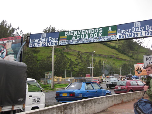
5 minutes down the road, we hit the border for Ecuador. Stood in line for about 15 minutes to get stamped out of Colombia and into Ecuador. Then walked down the street to get our car permit. All in all it was less than 20 minutes and best of all COMPLETELY free! I am loving South America borders.
WELCOME TO ECUADOR!
There are 2 routes from San Agustin towards the border. One involves a bit of back-tracking north to catch another highway back south again. I hate going backwards. The other route led us straight down to Ecuador but our friends at fromAtoB.org warned us of poor road conditions. Apparently the route between Mocoa and Pasto was very rough, rugged, and dangerous with lots of wash-outs, large trucks, and little clearance between you and a sheer cliff drop-off.
Being the kind of people who usually hear good advice and then completely disregard it, we of course chose to take the hard route.
It started off easy enough from San Agustin. We were on smooth well-maintained highway. After about an hour I started to wonder what the hell AtoB was talking about...
We were in some pretty remote country, apparently popular with Colombian FARC and guerrillas. The military presence was strong along the highway. We passed a few of these bad-*** truck TANKS.
We hit the town of Mocoa and the pavement ran out. We were driving on a very poor rubble road. I checked the maps and GPS a few times to confirm we were on the right track. Guess this must be the rough part they were talking about?
The poor road started to wind up into the side of the mountain. This road is the most direct route between the border and the interior of Colombia's Amazon jungle. It is primarily used by hardcore semi-trucks hauling logs/goods and the occasional lost gringo.
The road was chopped out of the side of the mountain. You could see many wash-outs where it completely had fallen away and road crews dug deeper into the side of the mountain to keep on truckin. The drive was actually quite beautiful. We were inside a mix of cloudforest and rugged mountains. We had to drive through tons of waterfalls and rivers which were slowly eroding into a muddy soup which made traction diffucult.
Eroding Cliff roads+No traction+No guardrails=Sketchy
In many parts you would have to stop before a blind corner and listen for a giant truck coming and sounding his horn. If you hear the horn you better back up and get the hell out of the way before you get run off the cliffs.
We plied this unpaved mountain route for most of the day. I think in total the route was less than 100 miles but it took us around 7 hours or so to cross. When we finally reached pavement I got out and kissed it.
Sweet sweet tarmac!
We pushed on spent a night at a hostel in Pasto near the Ecuador border. Next morning we were up and headed to the border.
One last stop before we cross though. Ever since I first saw a picture of the Las Lajas church I knew we had to visit it. The pictures made it same like a surreal castle nestled in a magnificent valley, the whole place looks unreal.
The inspiration for the church's creation was a result of a miraculous event in 1754 when an Amerindian named Maria Mueces and her deaf-mute daughter Rosa were caught in a very strong storm. The two sought refuge between the gigantic Lajas (Stone walls), when to Maria Mueces's surprise, her mute daughter, Rosa exclaimed "the mestiza is calling me..." and pointed to the lightning-illuminated silhouette over the laja. This apparition of the Virgin Mary caused pilgrimage to this location, with occasional miraculous cases of healing reported. The image on the stone is still visible today.
Ever since then the area has been blessed, the church was built between 1915 and 1949 with donations from the local churchgoers.
The intricate patterns and level of detail on the church is quite impressive.
In the parking lot, We saw our first BBQ'd Cuy (Guinea Pig) on a stick! Looks delicious!
5 minutes down the road, we hit the border for Ecuador. Stood in line for about 15 minutes to get stamped out of Colombia and into Ecuador. Then walked down the street to get our car permit. All in all it was less than 20 minutes and best of all COMPLETELY free! I am loving South America borders.
WELCOME TO ECUADOR!
VanIsle_Greg
I think I need a bigger truck!
great updates.
ripper1600
Adventure Seeker
This is a great write up and the blog and FB page are great especially the pictures.
defrag4
Road Warrior
After completing the worlds easiest border crossing we headed on down the highway into Ecuador.
We had technically been traveling in the Andes mountains for about a month now, but we never seem to get tired of the views.

Our first Llamas! Or Alpacas? I dont know the difference yet.

I had heard about the cheap gas in Ecuador. But man I was shocked when I finally saw it on the board. $1.45 USD/gallon. Insane! I pulled over giddy with delight and gave the man a $20. Fill her up!

The man gave me a confused look, gave me $10 change back immediatly and started pumping our gas.
Apparently within 50 miles or so of the border all the gas stations are limited at $10 per car to keep Colombians/Peruvians from coming across the borders and filling up. The gas station attendants are equipped with radios and are supposed to report to other stations in the area who has filled up already.
We got our $10, headed to the next town, and topped off the tank. No one bothered with the radio.
Our first stop in Ecuador is a popular town by the name of Otavalo. Otavalo is home to the biggest craft market in Ecuador. Locals travel from the surrounding areas to sell their goods here in the large open-air market.

Lauren tracked down a pair of Alpaca gloves, a Alpaca hat, and a kick-*** pair of ninja slippers. All for $7 USD. Crazy.
We camped for the night nearby and checked out some of the beautiful mountains surrounding Otavalo.

Cruising down the PanAm I knew we were supposed to eventually cross the equator (Protip: the word ECUADOR is spanish for EQUATOR) but I did not know exactly when. We ended up driving right by the damn thing without realizing it. Luckily we doubled-back trying to find a campsite and saw the GIGANTIC YELLOW TOWER LABELED EQUATOR. Not sure how we missed it the first time....


The lines in the concrete line up with the shadow of the tower to create a giant sundial.


It has always been a dream of mine to drink a beer on the equator. Well not really, but we had some in the truck so what the hell. Equator beers!

We ended up making friends with the tour-guy there who gave us a cool lesson on the equator itself and explained the many ancient monuments that surround the area. Pre-Columbian ancient civilizations have been using this particular area to accurately tell time, forecast future seasons/weather, and observe the cosmos for thousands of years. None of that water drains backwards, balance an egg, hoaky fake equator B.S. here. Sorry to disappoint guys.

Our new Equator/Ecuador friend said he was getting off in 30 minutes and asked if we would like to camp on his fathers farm just up the street for free? Why yes we would! We spent a wonderful night hanging out with our new friend, his father, and some amazing stars. The father even hooked up the water in his cabin for us if we were interested in taking freezing cold showers. We passed but appreciated the gesture! This was the first of many encounters with Ecuadorian locals, we found them all to be friendly and accommodating.


Check out Laurens new hat. 2 Happy campers.

Read the rest of the story and more pics on the blog at http://homeonthehighway.com/home-on-the-highway-crosses-the-equator/
We had technically been traveling in the Andes mountains for about a month now, but we never seem to get tired of the views.
Our first Llamas! Or Alpacas? I dont know the difference yet.
I had heard about the cheap gas in Ecuador. But man I was shocked when I finally saw it on the board. $1.45 USD/gallon. Insane! I pulled over giddy with delight and gave the man a $20. Fill her up!
The man gave me a confused look, gave me $10 change back immediatly and started pumping our gas.
Apparently within 50 miles or so of the border all the gas stations are limited at $10 per car to keep Colombians/Peruvians from coming across the borders and filling up. The gas station attendants are equipped with radios and are supposed to report to other stations in the area who has filled up already.
We got our $10, headed to the next town, and topped off the tank. No one bothered with the radio.
Our first stop in Ecuador is a popular town by the name of Otavalo. Otavalo is home to the biggest craft market in Ecuador. Locals travel from the surrounding areas to sell their goods here in the large open-air market.
Lauren tracked down a pair of Alpaca gloves, a Alpaca hat, and a kick-*** pair of ninja slippers. All for $7 USD. Crazy.
We camped for the night nearby and checked out some of the beautiful mountains surrounding Otavalo.
Cruising down the PanAm I knew we were supposed to eventually cross the equator (Protip: the word ECUADOR is spanish for EQUATOR) but I did not know exactly when. We ended up driving right by the damn thing without realizing it. Luckily we doubled-back trying to find a campsite and saw the GIGANTIC YELLOW TOWER LABELED EQUATOR. Not sure how we missed it the first time....
The lines in the concrete line up with the shadow of the tower to create a giant sundial.
It has always been a dream of mine to drink a beer on the equator. Well not really, but we had some in the truck so what the hell. Equator beers!
We ended up making friends with the tour-guy there who gave us a cool lesson on the equator itself and explained the many ancient monuments that surround the area. Pre-Columbian ancient civilizations have been using this particular area to accurately tell time, forecast future seasons/weather, and observe the cosmos for thousands of years. None of that water drains backwards, balance an egg, hoaky fake equator B.S. here. Sorry to disappoint guys.
Our new Equator/Ecuador friend said he was getting off in 30 minutes and asked if we would like to camp on his fathers farm just up the street for free? Why yes we would! We spent a wonderful night hanging out with our new friend, his father, and some amazing stars. The father even hooked up the water in his cabin for us if we were interested in taking freezing cold showers. We passed but appreciated the gesture! This was the first of many encounters with Ecuadorian locals, we found them all to be friendly and accommodating.
Check out Laurens new hat. 2 Happy campers.
Read the rest of the story and more pics on the blog at http://homeonthehighway.com/home-on-the-highway-crosses-the-equator/
defrag4
Road Warrior
Getting out to the deep amazon jungle on your own is a bit difficult. The primary form of travel in the Amazon is via the millions of rivers and water ways that wind through the jungle. There are very few roads and access via automobile is rare. We always regret not installing deploy-able Pontoons on the 4runner in situations like this...
I looked at our map of Ecuador and found the Cuyabeno National Park which appeared to be the most remote Amazon jungle area that we could actually drive to. Well you could not really drive INTO the park but you could get damn close. At the end of the road we would have to hitch a ride in a motorized canoe to actually make inside the parks boundary.
We hooked up with a cheap jungle lodge company in Quito that would agree to let us drive to the jungle ourselves. We had less than 24 hours to make it all the way across Ecuador to a random bridge in the jungle where there would (hopefully) be a canoe waiting to pick us up.
No big deal.
We hauled *** from Quito that afternoon. We crossed up and over the Andes mountains into a thick fog. We broke through the fog to see the low-lying Amazon jungle below us as far as the eye could see.

We dropped down from the mountains into the hot misty jungle. By this time night was falling, we found a spot to post up the night in front of an old clapboard house on stilts. This construction was typical of the area, reminded us of the homes seen along the Caribbean coasts of Central America.

Up in the morning and back on the road. We were zooming past miles and miles of oil pipelines and drilling rigs.

<RANT>
I usually try keep my personal politics off the blog but feel this needs to be shared. Ecuador is home to one of the largest oil reserves in the Americas. For over 25 years Texaco/Chevron and PetroEcuador have been pumping the hell out of the rainforest to the tune of 1.5+ billion barrels. Great for gas prices but absolutely devastating to the environment. The oil companies have been leaving behind their drilling waste products in large open pits in the rainforest. These pits overflow in the rainy season causing widespread contamination to the water table, soil, and farms of the local communities. There has been ongoing litigation in Ecuador between the 30,000+ locals effected in the rainforest and the oil companies who have exploited it. There is a great documentary called "CRUDE" which goes into much more detail on this situation. The movie is available streaming on Netflix. You can watch the trailer HERE on youtube. HERE is a short 60-minutes piece on the issue as well. I encourage readers to watch these segments and learn about the exploitation taking place, this kind of crap would absolutely not fly in the U.S.A.
</RANT>
Eventually we arrive at a lonely bridge in the middle of the jungle. We see no one. Crap! Did we miss the boat? We park and start looking around. We go underneath the bridge where we discover a toothless old man snoozing in a canoe. We gently nudge him awake. He sits up and I see he is wearing a Cuyabeno River Lodge t-shirt. Score! This was our guy.
We stash the truck at the old mans shack, load our stuff into the canoe, and hit the river. The small 5 horsepower motor slowly idled our canoe through the thick forest canopy. The morning was full of jungle sounds, frogs, monkeys, birds, insects. The sound of the jungle in the morning is something you must experience to believe.


We travel for around an hour or so via canoe seeing nothing but dense rainforest. We come around a bend and rising up out of the jungle is the "Cuyabeno River Lodge". The lodge consists of one large primary building and about 10 separate open-air cabanas.


We unloaded our stuff and were directed to our open-air cabin. Complete with hardcore bug net (very necessary out here in the jungle)

Home Sweet Home.

After a quick 30-min rest up the main bell sounded. We headed back up the clubhouse and met, Diego, our jungle guide. We also met a great group of ladies who have been volunteering with a street children education program in Quito for the past few months. They would be part of our group for the next few days.

First order of business. Suit up! We were all given a pair of knee-high rubber boats AKA Wellies to hike through the jungle with. Our guide tells us, "It's pretty wet out". (This would prove to be an understatement...)
Geared up we headed out into the jungle.

Read the rest of the jungle book and lots more pics on the blog at http://homeonthehighway.com/welcome-to-the-jungle-cuyabeno-reserve/
I looked at our map of Ecuador and found the Cuyabeno National Park which appeared to be the most remote Amazon jungle area that we could actually drive to. Well you could not really drive INTO the park but you could get damn close. At the end of the road we would have to hitch a ride in a motorized canoe to actually make inside the parks boundary.
We hooked up with a cheap jungle lodge company in Quito that would agree to let us drive to the jungle ourselves. We had less than 24 hours to make it all the way across Ecuador to a random bridge in the jungle where there would (hopefully) be a canoe waiting to pick us up.
No big deal.
We hauled *** from Quito that afternoon. We crossed up and over the Andes mountains into a thick fog. We broke through the fog to see the low-lying Amazon jungle below us as far as the eye could see.
We dropped down from the mountains into the hot misty jungle. By this time night was falling, we found a spot to post up the night in front of an old clapboard house on stilts. This construction was typical of the area, reminded us of the homes seen along the Caribbean coasts of Central America.
Up in the morning and back on the road. We were zooming past miles and miles of oil pipelines and drilling rigs.
<RANT>
I usually try keep my personal politics off the blog but feel this needs to be shared. Ecuador is home to one of the largest oil reserves in the Americas. For over 25 years Texaco/Chevron and PetroEcuador have been pumping the hell out of the rainforest to the tune of 1.5+ billion barrels. Great for gas prices but absolutely devastating to the environment. The oil companies have been leaving behind their drilling waste products in large open pits in the rainforest. These pits overflow in the rainy season causing widespread contamination to the water table, soil, and farms of the local communities. There has been ongoing litigation in Ecuador between the 30,000+ locals effected in the rainforest and the oil companies who have exploited it. There is a great documentary called "CRUDE" which goes into much more detail on this situation. The movie is available streaming on Netflix. You can watch the trailer HERE on youtube. HERE is a short 60-minutes piece on the issue as well. I encourage readers to watch these segments and learn about the exploitation taking place, this kind of crap would absolutely not fly in the U.S.A.
</RANT>
Eventually we arrive at a lonely bridge in the middle of the jungle. We see no one. Crap! Did we miss the boat? We park and start looking around. We go underneath the bridge where we discover a toothless old man snoozing in a canoe. We gently nudge him awake. He sits up and I see he is wearing a Cuyabeno River Lodge t-shirt. Score! This was our guy.
We stash the truck at the old mans shack, load our stuff into the canoe, and hit the river. The small 5 horsepower motor slowly idled our canoe through the thick forest canopy. The morning was full of jungle sounds, frogs, monkeys, birds, insects. The sound of the jungle in the morning is something you must experience to believe.
We travel for around an hour or so via canoe seeing nothing but dense rainforest. We come around a bend and rising up out of the jungle is the "Cuyabeno River Lodge". The lodge consists of one large primary building and about 10 separate open-air cabanas.
We unloaded our stuff and were directed to our open-air cabin. Complete with hardcore bug net (very necessary out here in the jungle)
Home Sweet Home.
After a quick 30-min rest up the main bell sounded. We headed back up the clubhouse and met, Diego, our jungle guide. We also met a great group of ladies who have been volunteering with a street children education program in Quito for the past few months. They would be part of our group for the next few days.
First order of business. Suit up! We were all given a pair of knee-high rubber boats AKA Wellies to hike through the jungle with. Our guide tells us, "It's pretty wet out". (This would prove to be an understatement...)
Geared up we headed out into the jungle.
Read the rest of the jungle book and lots more pics on the blog at http://homeonthehighway.com/welcome-to-the-jungle-cuyabeno-reserve/
defrag4
Road Warrior
While we were camped out in the jungle, our guide Diego was reveling us with stories of Ecuador's coast. Hearing tales of the Ruta Del Sol (Route of the Sun), Galapagos Islands, and fresh ceviche was enough to have us change our destination from mountains back to the coastline.
Headed out of the jungle we picked up a flat-tire, we easily tracked down a vulcanizadora in a nearby town. A 14-year old boy and his 8-year old brother came out to greet us. As they were removing the tire I realized it was a Tuesday and asked the kids if they should be in school. They both looked at me confused and said "This is our school". I felt guilty as I spent most of my 14-year old childhood doing my best to make my teachers lives a living hell. I think they should send little jerks like me to fix tires out in the jungle for a few months. I would be begging to come home and study. Perspective.
15 minutes and $2 later the tire was patched, filled, and we were back on the road.

We made a pitstop near the touristy town of Banos to relax for a few days at the wonderful Pequeno Paraiso, a highly recommended hostel/campground run by a friendly couple whom primarily cater to large "overlanding tour groups". These tour companies rig up giant buses with kitchens, camping equipment, and other overlanding gear, load 30 people on the bus and drive all over the place for months. A concept I had never heard of but is apparently very popular in South America, Europe, and Africa. Personally I don't think I could be stuck on a bus with 30 strangers for 6-months but some people must enjoy it. Luckily no group was there and we had full run of the joint. Its a great spot to hang for a few days.
We explored the areas waterfalls and recharged our batteries for a few days enjoying the cool mountain air.


From Banos we hit the highway, passing up and over the Andes, waving hello to Mount Cotopaxi on our way.

Pick your cut!

Eventually we were cruising closer to the coastline through some interesting dry tropical forest like landscape, it was full of these giant "bottle trees" which looked more like something out of Africa than South America. I later learned these are called "Ceibos" and actually are related to the famed Boabab trees of Africa.

Lauren, ever the queen of wildlife, picked up a new friend along the way, somehow this guy ended up landing on Lauren's hand while we were cruising at 55MPH. Amazing colors.

Soon we met up with the coastline itself, ah the Pacific, nice to see you again!

We discovered the "Route of the Sun" was more akin to the "Route of Grey". It is common knowledge (to us now as well...) that this time of year in Ecuador the coastline is primarily clouded over with grey clouds. Undeterred, We trekked on down to Puerto Lopez, our next destination.
Arriving in Puerto Lopez we quickly tracked down a little campground with wifi, hot showers, and a bar. Check, Check, and Check.
We made arrangements to head out to the "Isla de la Plata" the next morning. We had read that Isla de la Plata was the "poor mans Galapagos". Home to blue-footed boobies, frigate birds, and other forms of rare wildlife usually seen on the famed Galapagos islands. The difference was, a trip to the Isla de la Plata is $40 whereas a trip to Galapagos can range from $1000-$5000 depending. One day we would like to return and explore the real Galapagos. For now, the $40 Isla is more in our budget range.
Next morning we were out to beach where we were mingling with the fisherman hauling in the days catch. Seemed like 1/2 of the damn ocean was being hauled in to the shore.

We saw giant squids, tuna, dolphin, shrimp, you name it, being loaded by the crate into refrigerated trucks.


We weren't here for the food today, I doubt my stomach could handle eating a giant squid at 7:00AM anyway.
We met our boat captain, suited up, and walked out into the ocean to board our vessel. No fancy docks here, you gotta get wet to get onboard.


We were soon tooling along across the Pacific, the weather had cleared up and it was a gorgeous morning. My eagle-eyes caught many whales breaching the water off on the horizon. We also passed a few trawlers out hunting for shrimps or squid.

After a 2-hour ride we spotted a small island in the distance. From afar the island island appeared to have strange white patches all over it, as we approached I could see why, surrounding the island were thousands upon thousands of birds flying to and fro. The white patches? Awww ya thats doo-doo baby.


On the boat ride over we made friends with some fellow english-speakers, Aaron and Bri from Canada. We teamed up and got ready to hit the trails. However, once we actually made it onto shore we learned we were not allowed to just freely roam the island, we needed to go with a tour guide. Pretty lame, especially lame since we ended up standing around waiting for an hour for a late boat to arrive with more touristas. Oh well, We made the best of it practicing our best boobie jokes in preparation.
What kind of bees make milk? Boobies!
Finally our hike started and within 15 minutes we came across our first booby-sighting!

Read the rest of the story and loads more pics at http://homeonthehighway.com/ecuadorian-coast-isla-de-la-plata-and-boobies-galore/
Headed out of the jungle we picked up a flat-tire, we easily tracked down a vulcanizadora in a nearby town. A 14-year old boy and his 8-year old brother came out to greet us. As they were removing the tire I realized it was a Tuesday and asked the kids if they should be in school. They both looked at me confused and said "This is our school". I felt guilty as I spent most of my 14-year old childhood doing my best to make my teachers lives a living hell. I think they should send little jerks like me to fix tires out in the jungle for a few months. I would be begging to come home and study. Perspective.
15 minutes and $2 later the tire was patched, filled, and we were back on the road.
We made a pitstop near the touristy town of Banos to relax for a few days at the wonderful Pequeno Paraiso, a highly recommended hostel/campground run by a friendly couple whom primarily cater to large "overlanding tour groups". These tour companies rig up giant buses with kitchens, camping equipment, and other overlanding gear, load 30 people on the bus and drive all over the place for months. A concept I had never heard of but is apparently very popular in South America, Europe, and Africa. Personally I don't think I could be stuck on a bus with 30 strangers for 6-months but some people must enjoy it. Luckily no group was there and we had full run of the joint. Its a great spot to hang for a few days.
We explored the areas waterfalls and recharged our batteries for a few days enjoying the cool mountain air.
From Banos we hit the highway, passing up and over the Andes, waving hello to Mount Cotopaxi on our way.
Pick your cut!
Eventually we were cruising closer to the coastline through some interesting dry tropical forest like landscape, it was full of these giant "bottle trees" which looked more like something out of Africa than South America. I later learned these are called "Ceibos" and actually are related to the famed Boabab trees of Africa.
Lauren, ever the queen of wildlife, picked up a new friend along the way, somehow this guy ended up landing on Lauren's hand while we were cruising at 55MPH. Amazing colors.
Soon we met up with the coastline itself, ah the Pacific, nice to see you again!
We discovered the "Route of the Sun" was more akin to the "Route of Grey". It is common knowledge (to us now as well...) that this time of year in Ecuador the coastline is primarily clouded over with grey clouds. Undeterred, We trekked on down to Puerto Lopez, our next destination.
Arriving in Puerto Lopez we quickly tracked down a little campground with wifi, hot showers, and a bar. Check, Check, and Check.
We made arrangements to head out to the "Isla de la Plata" the next morning. We had read that Isla de la Plata was the "poor mans Galapagos". Home to blue-footed boobies, frigate birds, and other forms of rare wildlife usually seen on the famed Galapagos islands. The difference was, a trip to the Isla de la Plata is $40 whereas a trip to Galapagos can range from $1000-$5000 depending. One day we would like to return and explore the real Galapagos. For now, the $40 Isla is more in our budget range.
Next morning we were out to beach where we were mingling with the fisherman hauling in the days catch. Seemed like 1/2 of the damn ocean was being hauled in to the shore.
We saw giant squids, tuna, dolphin, shrimp, you name it, being loaded by the crate into refrigerated trucks.
We weren't here for the food today, I doubt my stomach could handle eating a giant squid at 7:00AM anyway.
We met our boat captain, suited up, and walked out into the ocean to board our vessel. No fancy docks here, you gotta get wet to get onboard.
We were soon tooling along across the Pacific, the weather had cleared up and it was a gorgeous morning. My eagle-eyes caught many whales breaching the water off on the horizon. We also passed a few trawlers out hunting for shrimps or squid.
After a 2-hour ride we spotted a small island in the distance. From afar the island island appeared to have strange white patches all over it, as we approached I could see why, surrounding the island were thousands upon thousands of birds flying to and fro. The white patches? Awww ya thats doo-doo baby.
On the boat ride over we made friends with some fellow english-speakers, Aaron and Bri from Canada. We teamed up and got ready to hit the trails. However, once we actually made it onto shore we learned we were not allowed to just freely roam the island, we needed to go with a tour guide. Pretty lame, especially lame since we ended up standing around waiting for an hour for a late boat to arrive with more touristas. Oh well, We made the best of it practicing our best boobie jokes in preparation.
What kind of bees make milk? Boobies!
Finally our hike started and within 15 minutes we came across our first booby-sighting!
Read the rest of the story and loads more pics at http://homeonthehighway.com/ecuadorian-coast-isla-de-la-plata-and-boobies-galore/